In the recent Indo -China border stand off, a little known border road called the Darbuk-Shyok-Daulat Beg Oldie (DSDBO) road suddenly sprang into prominence and started occupying the center stage of the strategic debates . This road took nearly 20 years for India to build on its own side of the recognized LAC. So why it has become so controversial for India and China in the current conflict?
Of the many triggers cited for the China’s People Liberation Army’s provocative actions along the line of actual control (LAC) in eastern Ladakh, Indian insistence, despite China’s protest, to go ahead with the construction of its 255-km long Darbuk-Shyokh-Daulat Beg Oldie (DSDBO) all-weather road connecting Leh to DBO is perhaps the most important one .
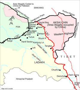
Daulat Beg Oldie also called DBO is located in the northernmost corner of Indian territory in Ladakh. Indian Army deployed in this area call it their Sub-Sector North. DBO has the world’s highest airstrip, originally built during the 1962 war but remained unused until 2008. Grant it to the foresight of the Indian defense planners , a decision was taken in 2009 itself, to revive this short airfield among India’s many Advanced Landing Grounds (ALGs) along the LAC. Soon an Indian Air Force (IAF) , Russian origin, sturdy workhorse, Antonov An-32, designed for short landing and take-off was successfully attempted for roll-off landing and take off mission on this old abandoned airfield.
However, in August 2013, after carrying out the necessary repairs, IAF again created history by landing one of its newly acquired Lockheed Martin C-130 J Hercules transport aircraft at the DBO Advance Landing Ground to signal the revival of DBO ALG. With this routine landing it was proved that a regular all weather supply line through air can be maintained in this area round the year. With this, Indian Army’s need to send helicopters to paradrop supplies in small quantities to Army formations deployed in this in-accessible terrain along our disputed frontier, came to an end.
However, maintenance of this Air Strip and sustenance of supplies to forward troops through air alone, remained daunting with its own inherent limitations. That is when army, with the help of one of its own magnificent engineering formations, called the Boarder roads Organization (BRO) embarked upon an ambitious project of connecting DBO with Leh by a high quality, heavy duty, all weather road passing through one of the most inaccessible and treacherous terrain that braves the world’s harshest climates of the world. The climate in this area remains so adverse, that it used to give BRO only few months every year to carry out construction activities in this difficult area.
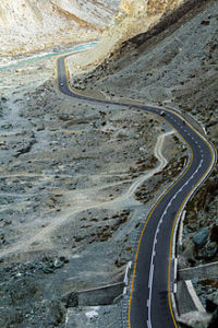
Running parallel to the LAC, the DSDBO road, passes through elevations ranging from 13,000 ft to 16,000 ft . As stated, it took BRO almost two decades to perform this remarkable feat of constructing this difficult road. The strategic importance of this road is not only that it connects Leh to DBO, but it also almost touches the base of the Karakoram Pass that separates China’s Xinjiang Autonomous Region from Ladakh.
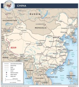
Since the DSDBO provides Indian Army access to the section of the Tibet-Xinjaing highway G-219 that technically passes through Indian territory, illegally occupied by China in Aksai Chin in 1962, it has become a major cause of worry for the PLA. DSDBO runs almost parallel to the LAC at Aksai Chin, the eastern ear of erstwhile Jammu and Kashmir state that China occupied in the 1950s, leading to the 1962 war in which India had faced a humiliating defeat.
The emergence of DSDBO’s in face of such adversity and Chinese resistance, not only annoyed China but also caused considerable panic in PLA. DBO itself is less than 10 km west of the LAC at Aksai Chin. A military outpost was long created in DBO in reaction to China’s occupation of Aksai Chin, and is at present manned by a combination of the Army’s Ladakh Scouts and the paramilitary Indo-Tibetan Border Police (ITBP). Both forces regularly patrol the LAC.
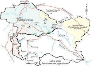
The additional strategic considerations in the area is that the west of DBO is the region where China abuts Pakistan in the Gilgit-Baltistan, once a part of the erstwhile Kashmir principality. This is also the critical region where China is currently constructing the China-Pakistan Economic Corridor (CPEC) in Pakistan-Occupied Kashmir (PoK), which India has objected . This is also the region where Pakistan had ceded over 5,180 sq km of PoK to China in 1963 under a Sino-Pakistan Boundary Agreement, contested by India
That is why Chinese are so determined in their intent to neutralize their perceived threats emanating from above Indian activities and decided to resort to build-up its strength along the Galwan River region. This is the valley that overlooks DSDBO and by showing its strength there, Chinese wanted to intimidate India into abandoning their DSDBO project. In case of Indian defiance, PLA has all the intensions to interdict this road by force, as and when the situation demands. It is trying to create vantage positions in the area to undertake that task when asked for.
In what is explained above lies the real danger to Indian security. DSDBO is an important strategic need of the Indian Army in that region. That is why, the Indian army, in a very smart and professionally commendable maneuver moved swiftly and stealthily, taking China completely by surprise, and most daringly, occupied all the commanding heights of this region that has snatched away the advantages that China had tried to gain through its early treacherous moves. This tit for tat treatment meted out by the Indian Army to the PLA has become very embarrassing for PLA brass, putting them in a very unenvious tight spot because this kind of audacity was not expected by them from the Indian Army. China has been completely beaten in its own game in this area and paying for underestimating the capabilities of Indian army and Indian govt under a strong leadership.
So this is where we stand today.


